
From the Welsh hills to the Bristol Channel, we are mapping every stretch on the Severn with verified permits, parking and access information.
Important:
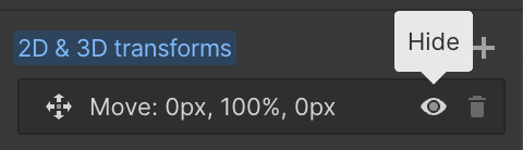
This component uses Transforms (Move Down 100%) to hide and show modal (on Tablet) so that filters apply once the user hits the apply button (optimal UX). Using the display: hidden will prevent the apply button from working.
To show and hide the modal for editing purposes on Tablet:
To show and hide the modal for editing purposes on Tablet:
- Select the filters2_filters-wrapper inside the parent div filters2_layout div.
- Hit the Hide button and it will show (yes this is counterintuitive).
Thank you! Your submission has been received!
Oops! Something went wrong while submitting the form.


Filters
The Albrighton — SAC
From
Concrete culvert at downstream end of STF Sydney Avenue
To
Garden of first bankside house (where The Royce section starts)
Membership Only
~0.2 mi
SY1 2JD
Permitted

Barbel
Chub
Dace
Roach
Pike
The Royce — SAC
From
Above Telford Way road bridge (some houses close to river)
To
Upstream end of Pimley Rough (where river runs over bedrock, joins Pimley)
Membership Only
Needs Verification mi
Permitted
Barbel
Chub
Bream
Salmon
Pike
Pimley Rough — SAC
From
Back of Coracle Pub car park, Sundorne Road, Shrewsbury
To
Sewage works (downstream limit)
Membership Only
Needs Verification mi
SY1 2RP
Permitted
Barbel
Chub
Pike
Perch
Roach
Pimley Manor — SAC
From
Downstream of sewage works (Pimley Rough lower limit)
To
Inlet of stream below A5 bridge
Membership Only
Needs Verification mi
SY5 8JR
Permitted
Barbel
Chub
Pike
Perch
Salmon
Underdale — BAA
From
Either side of Telford Bridge, Underdale, Shrewsbury (right bank)
To
~1 mile spread either side of Telford Bridge
Membership Only
~1 mi
SY2 5XT
Not Permitted
Salmon
Barbel
Bream
Chub
Carp
STF Emstrey
From
First field upstream of A5 bridge, bears left into long straight then sweeping right-hand curve
To
Downstream limit of large sweeping bend (~1.5 miles)
Day Ticket & Season
~1.5 mi
SY5 6QP
Not Permitted
Barbel
Chub
Salmon
Bream
Roach
Llyn Clywedog area — Prince Albert Angling Society
From
Needs Verification (multiple beats, upper/mid Severn)
To
Needs Verification
Membership Only
Permitted
Barbel
Chub
Salmon
Sea Trout
Brown Trout
STF Quarry Park — River Severn, Shrewsbury town centre
From
Quarry Park, Shrewsbury (STF water, town centre)
To
Downstream limit of Quarry Park
Day Ticket & Season
SY1 1RU
Not Permitted
Roach
Dace
Bleak
Perch
Chub
STF Monkmoor
From
Downstream end: New Park Road / Sultan Road junction (red arrow on map)
To
Weir Pool (upstream limit)
Day Ticket & Season
~0.75 mi
SY2 5TL
Not Permitted
Barbel
Chub
Salmon
Pike
Perch
Brook House Farm / Brooke Cottage — River Severn, Crewe Green
From
Brook House Farm Camping & Caravan Site, Crewgreen SY5 9BU (upstream end of beat)
To
Beat length Needs Verification
Private / Syndicate
Needs Verification mi
SY5 9BU
Not Permitted
Barbel
Trout
Chub
Dace
No results found.
There are no results with this criteria. Try changing your search.
