
From the Welsh hills to the Bristol Channel, we are mapping every stretch on the Severn with verified permits, parking and access information.
Important:
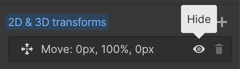
This component uses Transforms (Move Down 100%) to hide and show modal (on Tablet) so that filters apply once the user hits the apply button (optimal UX). Using the display: hidden will prevent the apply button from working.
To show and hide the modal for editing purposes on Tablet:
To show and hide the modal for editing purposes on Tablet:
- Select the filters2_filters-wrapper inside the parent div filters2_layout div.
- Hit the Hide button and it will show (yes this is counterintuitive).
Thank you! Your submission has been received!
Oops! Something went wrong while submitting the form.


Filters
Newhalls Meadow, Stourport — BAA
From
Newhalls Meadow, Stourport-on-Severn (public car park near former Leisure Centre)
To
Downstream extent Needs Verification
Membership Only
Needs Verification mi
DY13 0AA
Not Permitted

Roach
Bream
Chub
Pike
Barbel
Lickhill Manor
From
Lickhill Manor Caravan Park, Stourport-on-Severn (upstream limit)
To
Downstream limit (extent Needs Verification)
Membership Only
Needs Verification mi
DY13 0DH
Not Permitted
Barbel
Chub
Roach
Dace
Bream
Larford Lakes — River Severn
From
Seed Green area (above Lincombe Weir, upstream limit)
To
Lincombe Weir downstream limit
Day Ticket Only
~1 mi
DY13 0SQ
Permitted
Barbel
Chub
Bream
Dace
Roach
Winnall — KDAA
From
Top car park (north/upstream end)
To
Bottom car park (downstream end), ~20 pegs
Membership Only
Needs Verification mi
WR9 0HT
Not Permitted
Barbel
Bream
Roach
Chub
Perch
Stourport — White Swan Piscatorials
From
WSP Stourport upstream limit (DY13 area)
To
WSP Stourport downstream limit
Membership Only
DY13 9PA
Not Permitted
Barbel
Chub
Roach
Dace
Pike
Hampstall Inn, Astley Burf
From
Hampstall Inn, Astley Burf (upstream limit)
To
Short stretch adjacent to the inn (downstream limit)
Day Ticket Only
<0.25 mi
DY13 0XN
Not Permitted
Barbel
Chub
Roach
Dace
Perch
Rosewaters Cottage — River Severn, Astley Burf
From
Rosewaters Cottage, Astley Burf (upstream end)
To
Short stretch downstream
Private / Syndicate
WR8
Not Permitted
Boreley Angling Club — River Severn, Lineholt
From
Boreley, Ombersley area (below BAA Ladyham stretch, above Briskers AC Winnals)
To
Downstream extent of Boreley AC water
Membership Only
DY13
Not Permitted
Barbel
Chub
Bream
Roach
Lineholt
From
Lineholt area (above BAA Ladyham stretch, between Stourport and Worcester)
To
Downstream extent Needs Verification
Day Ticket Only
Needs Verification mi
WR9
Permitted
Barbel
Chub
Roach
Bream
Lenchford Riverside Inn, Shrawley
From
Lenchford Inn, Shrawley area (Needs Verification exact location)
To
Short stretch adjacent to inn
Private / Syndicate
<0.25 mi
WR6 6TB
Not Permitted
Barbel
Chub
Roach
Dace
Perch
No results found.
There are no results with this criteria. Try changing your search.
